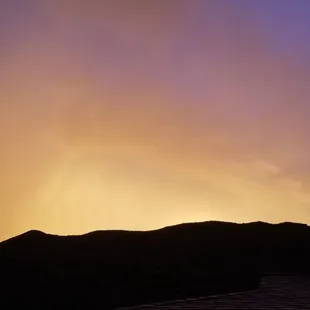
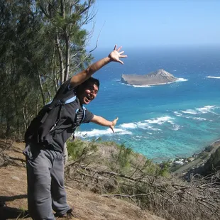
Sky on fire one end
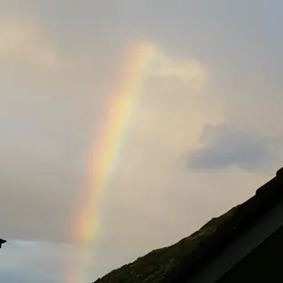
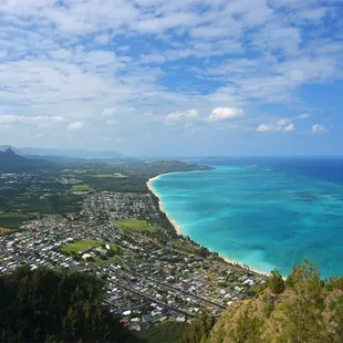
Somewhere over that rainbow is downtown honolulu
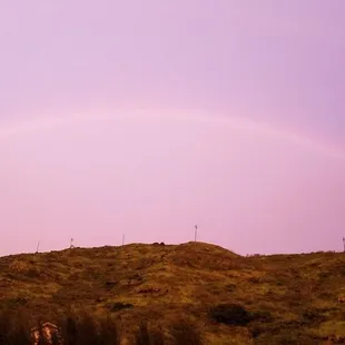
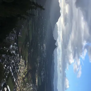
Rainbow
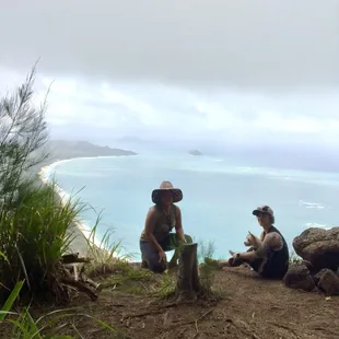
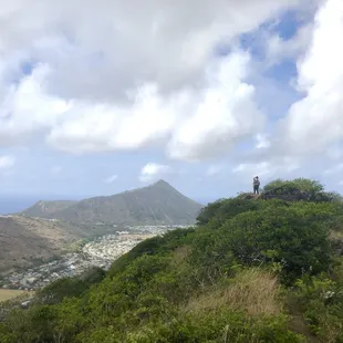
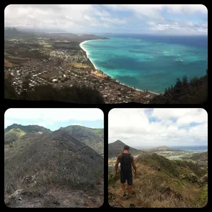
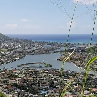
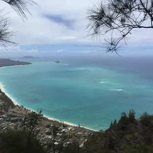
Top with view of Waimānalo
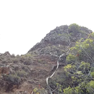
The way down if lost

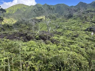
Bushwacking
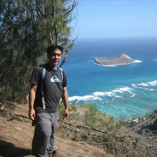
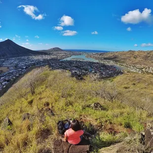
Final destination
Great view to reward you for all your effort. Enjoy!
Cool views of kokohead
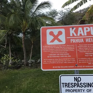
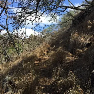
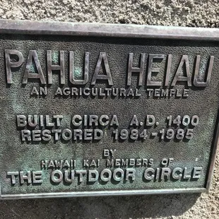
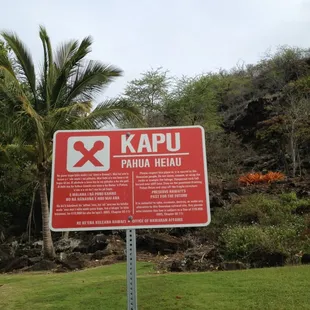
Entry

Kelly H.
Apr 13, 2020
Believe the reviews, this trail is overgrown...but don't let that stop you from going! It starts in a neighborhood in Hawaii Kai so be respectful of the residents and park a block or so away from the hike and walk down to the cul de sac. When you get to the Heiau there are no hiking signs, so this is your own choice to move on or not. If you decide to continue on, go to the left of the heiau and follow the overgrown path with pink and yellow ribbons. It's not difficult to find. Once you get up on top of the trail it's simple to follow. Be sure to wear a hat and/or sunscreen! It was really hot when we went and I had wished I wore a hat and pants. The trail took us through some cool terrain and was shady after the first half hour. It was windy at the top but totally worth it! It took me 1 hr and 20 min to get to the top and I stopped a few times to have water and take a breath. The views were spectacular. I can't wait to do this hike again. Total it took a little under 3 hours. I highly recommend it!
Read More
Angela W.
Nov 25, 2018
Very easy to get lost. Bushes were very high which can hide holes and rocks. Look for ribbons and use intuition to go up. Do not go into people's yards.Once you reach pine forest the summit is very near. But this is the trickiest part. Keep a sharp eye out for the ribbons. Just remember to keep going up not around the cliff. Views are awesome during and the end.
Read More
Shianne S.
Sep 29, 2016
Loved this hike besides the start when I carefully entered around the heiau. Always wonder if there's a different entrance besides that due to walking near sacred ground...but anyway, best views on this hike! Although it was intensely hot when I went and there was no breeze until we got to the leeward side. It can be a bit extensive depending on how far you want to go.Pack a hat, sunblock, lunch, and lots of waterDefinitely top 3 of my favorite hikes on the island (& I've done quite a few).
Read More
Amylynne F.
Jul 15, 2018
This was a fun hike! The address is WRONG! Google 7144 makahuena place and that's how you find the trailhead. Be respectful when parking as it's a residential neighborhood. Go early Bc it's so hot and though we enjoyed a nice breeze for most of it, it was very very hot at times. Previous reviews mentioned it's very hard to find the trail. It is and it isn't. Find the sacred site, be respectful, and stay left and head up and west to the ridge line. It is well marked with pink ribbons the whole way but it is definitely overgrown. The branches didn't bother me but my gf complained the whole way it was agony. Leading her and a blind dog up the trail, it took about 2 hours to get to the top and enjoy it, then an hour 20 down. It was fun. And no one else was on it so I felt really lucky!
Read More
Tim L.
Mar 6, 2017
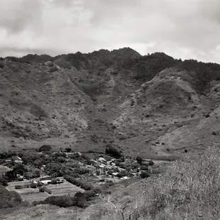
I'm giving four stars for Kamiloiki ridge. But we continued onward, upward, downward, then upward again to the Kaupo 2 ridge/summit which was super awesome for the rock climbing and bouldering.But for Kamiloiki, I found the hike in/out to the ridge rather boring. But the views up at the top -- outstanding! Some of the best panorama views I've seen up on the ridgeline. We lucked out and did this hike last Saturday (4 Mar 2017) when it was dry and not super sunny/hot. A good portion of this hike is unshaded so you want to start early or on a nice day like we had. I think it's about an hour hike each way to/from the ridgeline. Pretty easy with a mostly clearly marked trail up along the ridge and forests to the top. The most difficult (trail spotting) section was the very beginning just to get up above the cul de sac. Once atop the ridge, just head up and follow the trail.Once at the ridgeline, after having taken in the amazing views of Waimanalo below, head to your left (northwest) along the ridgeline over to the electric poles that are visible about 1/2 mile away (maybe 30 minutes hiking time). There's even better views down on Waimanalo and the Windward side from up there.Bring at least one liter of water unless it's hot and sunny where you'd want more. The hike isn't too physically challenging; just a long trek upwards to gain about 1200 feet of elevation.
Read More
Rhoda H.
Aug 29, 2020
Trail closed. A representative from OHA kindly informed me that the heiau encompasses the entire base of the cliff side property. It's an ancient archaeological site and should be respected. OHA is currently working on rebuilding and preserving this heiau. I wasn't aware that the heiau extended all the way to the fence line so I will respect their request to stay off their property. I hope others do the same.
Read More
Natalie R.
Mar 10, 2018
Not a maintained hike. Overgrown bushes and trees. Sacred area at the base of the hike. No Trespassing signs posted. A friendly resident saw us trying to find the start and he told us the hike started on the left. We attempted to push our way through bushes for a few minutes and shortly gave up after getting multiple bug bites and scratches from the poorly maintained trail. It looks like nobody has hiked it in a very long time. Bring a machete with you if you plan to do this hike.
Read More
Kyle H.
Nov 20, 2012
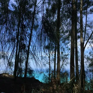
I loved the variety of terrain this hike provided as well as the awesome cardio all the way through! Our hike began by climbing over some lava rock at the back of a heiau, which was located very surprisingly close to the main road. http://www.yelp.com/biz_photos/kamiloiki-ridge-trail-honolulu?select=5gU05COGWZ6TCjdW3mG0ow#AVo6JYwUbWJ1Aaj_sdeqqQFrom that point and for most of the next 30-40 minutes, depending on your pace, it's a zig-zag and mild uphill climb across rocks, mostly dry and well-trodden path (during this portion you can see into the valley and see the cookie-cutter neighborhood from above), and through a beautiful breezy pine forest to one of the first ridge viewpoints. http://www.yelp.com/biz_photos/kamiloiki-ridge-trail-honolulu?select=5gU05COGWZ6TCjdW3mG0ow#qlvAyJmpy9EG1NUToZMrbwWhen you get to this lookout, you are made of stone if your jaw doesn't drop at the pleasure of such a gorgeous view. http://www.yelp.com/biz_photos/kamiloiki-ridge-trail-honolulu?select=5gU05COGWZ6TCjdW3mG0ow#2GNcaYZkvHJqRoysM9MGBwThere's more to come, a few minutes more up the ridge, you get one the best vantage points, you're able to see on both sides of the ridge, the ocean seemingly surrounding the one point where you stand!http://www.yelp.com/biz_photos/kamiloiki-ridge-trail-honolulu?select=5gU05COGWZ6TCjdW3mG0ow#wnTlyrr3Ls-hMOXUEfY0fQContinuing on, there are a few steep areas to navigate down and up, it looks much more technical and scary than it really is. http://www.yelp.com/biz_photos/kamiloiki-ridge-trail-honolulu?select=5gU05COGWZ6TCjdW3mG0ow#go-Zr8Z8r14zpTwcn5AnlQhttp://www.yelp.com/biz_photos/kamiloiki-ridge-trail-honolulu?select=5gU05COGWZ6TCjdW3mG0ow#V0FsXbFTfcVk8zJtuUSX4gAfter this point, you're pretty much home free and you've made it to the area accessible from the Makapu'u lookout point (where you can get to the hang-gliding jump points). This was definitely one of the most favorite hikes I've done. Gorgeous views and great workout!
Read More
Nimai W.
Oct 18, 2014
"Let's-go-on-a-hiiiiiike" (FB Message)"Take-me-on-a-hike-with-youuuuuu" (Text Message)"Hikehikehikehikehikehikehiiiiiiiiiiike" You're Cool (Yelp Compliment)"Lets-go-on-an-adventurrrrrrrrrre.. Did you get my other messages??" (Email)* * *Got a friend who isn't a hiker, desperately trying to hike with you? Take them to Kamiloiki. It will either scare them off and they'll never bother you again. Or you can see how they handle an easy trail with tough conditions. It's an underwhelming, pain-in-the-ass, itchy & scratchy, hike. (heh-heh) That is, until you come upon that final rise, and it opens up to one of the most spectacular views of the Windward side I have ever seen. It literally took my breath away. Hike Time: about 3-4hrs+ roundtripMost of this hike is shadeless. If you go in the middle of a nice day, it will be brutally hot. It took me and my gf about 5hrs! However, that includes about an hour of chill/shooting time at the end, and lots of small water breaks. AND about 20 minutes of us getting lost on our way back down. Difficulty level: Beginner ChallengingThe hike itself is mostly a gradual slope, and not very challenging. The hard part for me was dealing with the heat. I drank about 2L of water. Bring more than you think you'll need.Somethings you'll deal with on this trail:Low Lying shrubsThese little bastards will leave you scraped up and possibly bleeding (I was!) Consider wearing pants. Tall Grass (head high)Starting about halfway up the trail, you'll begin to encounter LOTS of this stuff (see pics). I was hiking without a shirt because of the heat, my arms, and stomach were itching/burning like crazy!! So I gave in and put the shirt back on. Next time I might pack a long sleeve just to wear during these parts.Crumbly rocksThese old ridges.. are old. Not only do you have to watch your step for loose rocks, but for roots sticking out. I have good boots, so I didn't slip during this hike, but I did trip on a few roots. Finding the trail headFollow the Yelp map/directions, and park on the street. As always, be respectful of residence. Leave no trash, be quiet. Locate the Heiau at the end of the cul-de-sac, you'll see a "Kapu" sign. Take the stairs up, on the right side of the Heiau, and once above it, walk to the left behind/around it. You'll come to some tall grass and see a faint trail and hopefully a ribbon. As you continue on, follow the ribbons until the trail becomes obvious. When coming back down from the hike, BE CAREFUL to follow the ribbons. It does get confusing.It's not the longest hike, but unless you're running out of water or daylight - keep going! This hike really is all about the view.
Read More
Yuko A.
Jul 30, 2012
I haven't been hiking in about a month and a half so I was stoked to get out in the mountains again. Kamioiki had been on my list for a while and I was excited to do my 20th hike! Unfortunately this means 30 more, by December 2012. AHHH I love going on hikes that 1. I haven't done 2. have rewarding views 3. are not crowded and this hike definitely hit all three points. The first 3/4 of it is pretty barren, with NO shade. Lucky for us it was windy so we didn't get as hot as I'm sure others do on sunny/non-windy days. I didn't find it to be too difficult, a little bit of rock climbing but nothing that can't be done by a beginner hiker. The hardest part is near the end where there are little inclines you have to climb up, but seriously nothing too hard that will get your buns burning. It is mostly shaded in the trees so its not only a nice change of scenery but much cooler. Plus your walking on pine needles making the ground soft and easy to walk on. The view is of course unreal. You get a beautiful view of Waimanalo, Olomana, and almost to Kaneohe. The water was so crystal blue it made me want to just jump into the ocean....If only we could fly. You go down the same way you go up so get ready to walk along those barren rocks again. It took us about 2 hours so a perfect morning or mid-afternoon hike. I would rate it as a beginner-intermediate hike. YELP 365: 200/365
Read More